 |
| Australis Cruises Cape Horn & Patagonia - Punta Arenas, Chile |
Patagonia is a remote region shared between the two countries of the South American cone, Chile and Argentina. The Chilean part of Patagonia stands out as one of the most beautiful and diverse regions in the world, with its stunning natural landscapes, rich culture and varied offer of activities, it is an ideal destination for adventure, nature and history lovers.
Chilean Patagonia is today a first-class tourist destination. In this post, we tell you some of the places you can not miss if you want to know this wonderful region in the far south of Chile.
A very brief History
Before European arrival in the 16th century, Patagonia was home to indigenous groups: the Tehuelches (Aonikenk) on the mainland, the Kaweskar in the interior channels, the Selk'nam in Tierra del Fuego, and the Yaganes in the far south.
Ferdinand Magellan was the first European to reach Patagonia in 1520, encountering the Tehuelches, whom he called "Patagonians" due to their height. Later expeditions explored the region, but permanent settlements were rare. In 1584, Pedro Sarmiento de Gamboa founded Ciudad del Rey Don Felipe in the Strait of Magellan, but harsh conditions led to its abandonment. Rediscovered by Thomas Cavendish, it became known as Port Famine.
Chilean Patagonia's colonization gained momentum in the 1870s to define borders and boost economic growth. Sheep farming became its backbone, with settlers from Chile and Europe—mainly Germans, English, and Croatians—facing isolation, hardships, and adventure.
How to get to Patagonia, Chile
Chilean Patagonia, the southernmost region of South America, includes the southern part of the Lakes Region, Aysén, and Magallanes (excluding the Antarctic territory). Due to its rugged geography, land access is only possible up to Aysén, while reaching Magallanes by road requires passing through Argentina. However, flights operate regularly.
Daily flights from Santiago’s Arturo Merino Benítez Airport connect to Puerto Montt (gateway to Northern Patagonia) and Punta Arenas, with seasonal flights to Puerto Natales. Main airports include El Tepual (Puerto Montt), Teniente Julio Gallardo (Puerto Natales), and Carlos Ibáñez del Campo (Punta Arenas). The Guardiamarina Zañartu airfield in Puerto Williams is crucial for Antarctic-bound tourists. Airlines operating in the region include LATAM, Sky Airline, JetSmart, and Aerovías DAP.
 |
| Paine Mountains, Magallanes Region |
Chilean Patagonia, stretching from 41° to 56°S, has a temperate to cold climate with significant temperature variations. Northern Patagonia experiences abundant rainfall year-round, with summer temperatures exceeding 20°C and winter often below freezing.
Further south, the climate is drier and colder. Summer highs reach 15–20°C, while Torres del Paine enjoys a milder microclimate despite its unpredictable weather. Winter temperatures in Southern Patagonia typically range from 0 to 5°C, with lows reaching -10°C or lower.
Between December 15 and January 15, sub-Antarctic Patagonia enjoys extended daylight, with sunset near 23:00 and sunrise around 03:00, creating a twilight effect in the southern horizon.
Tourist places in Southern Patagonia
Chilean Patagonia's southernmost region stretches from the Southern Ice Fields to Cape Horn, covering the entire Magellan Region. This remote area has a harsh climate, except in summer, and is home to some of Chile’s most iconic tourist spots.
Keep in mind that weather in southern and sub-Antarctic Patagonia can change drastically from one day to the next, even in spring and summer. If you're lucky, clear skies will make for an unforgettable experience. Otherwise, the weather might not be on your side, affecting part of your visit.
Punta Arenas, Regional capital
Torres del Paine National Park
 |
| Photo by Alex Wolowiecki on Unsplash |
Torres del Paine, the region’s main protected area and a top tourist attraction, lies 312 km north of Punta Arenas and 150 km from Puerto Natales. Declared a UNESCO Biosphere Reserve in 1978, this 242,242-hectare park boasts granite peaks, turquoise lakes, and rivers fed by the Southern Ice Fields, making it a paradise for nature and adventure lovers.
Popular activities include trekking the iconic "W" and "O" circuits, horseback riding through breathtaking landscapes, fly fishing, and kayaking on the Serrano River with stunning views of the Balmaceda, Serrano, and Tyndall glaciers. For more details about this stunning destination, visit our post on Torres del Paine National Park.
Tierra del Fuego Island (Land of Fire)
 |
| Nuestro Diario de Aventuras |
Tierra del Fuego, Chile’s largest island, sits at the southernmost tip of South America. Shared with Argentina, the island spans 47,992 km²—Argentina holds the eastern 18,507 km², with Ushuaia as its capital, while Chile governs the western and southern 29,485 km², with Porvenir as its capital.
Whale watching tours around Carlos III Island
Season: December to April
Located in the Strait of Magellan, six hours by boat from Punta Arenas, the Francisco Coloane Marine Park spans 67,000 hectares and was Chile’s first marine protected area. Here, you can spot humpback whales (Megaptera novaeangliae), minke whales, dolphins, sea lions, penguins, and various seabirds.
The park’s rich ecosystem includes the nearby Santa Ines Glacier, which may be visited depending on the tour. For availability, check with local agencies in Punta Arenas, the departure point.
Parque del Estrecho and Fuerte Bulnes
62 km south of Punta Arenas, Fuerte Bulnes is a reconstruction of Chile’s first settlement in the Strait of Magellan (1843). It features trails, viewpoints, and historical sites like a chapel, jail, stables, and cannon yard. In 1848, its inhabitants relocated, founding Punta Arenas.
Nearby, Puerto del Hambre preserves the ruins of Rey Don Felipe, a Spanish colony where settlers perished from starvation in 1584.
Since 2008, Punta Santa Ana’s 250 hectares, including both sites, have been part of Parque del Estrecho de Magallanes. Visit the Official Site for details.
La Cruz de los Mares (Cross of the Seas)
Perched 340 meters above sea level on Cape Froward, Strait of Magellan, 48 nautical miles south of Punta Arenas, this cross marks the southernmost point of continental Chile and South America. Originally built in 1913, it has been rebuilt multiple times due to harsh weather. The current structure commemorates Pope John Paul II’s 1987 visit.
In 1587, English explorer and privateer Thomas Cavendish named the cape for its fierce winds and torrential rains. Local agencies offer zodiac or kayak trips to Cape Froward, followed by a hike to the cross.
Faro San Isidro (San Isidro Lighthouse)
Inaugurated in 1904, 75 km south of Punta Arenas, at the southern tip of the Brunswick Peninsula, Magallanes Region. It symbolizes the era of intense maritime traffic through the Strait of Magellan before the Panama Canal. Now restored, it serves as a lodge and tourist site.
Surrounded by native forests and panoramic views of the Strait of Magellan and Tierra del Fuego, visitors can enjoy kayaking, hiking to Bahía El Águila and Mount Tarn—climbed by Charles Darwin—or exploring Cape Froward, the continent’s southernmost point.
'Maggiorino Borgatello' Salesian Museum
Located at 336 Bulnes Avenue, next to Maria Auxiliadora "Don Bosco" Church in downtown Punta Arenas, this museum was founded in 1893 and bears the name of its founder, a key missionary among Tierra del Fuego’s natives.
One of Chile’s most important museums, it showcases Patagonian history, ethnography, flora, fauna, and industry. Its four exhibition levels cover aboriginal life, Salesian missions, regional biodiversity, commerce, cattle raising, and the oil industry. The museum also houses a valuable library with over 4,000 books and audiovisual materials. A major attraction, it draws both national and international visitors.
Punta Arenas Main Square

Named Plaza Muñoz Gamero after a former governor, this square is a key meeting point for city tours in the Patagonian capital. It is surrounded by elegant buildings reflecting an era of economic splendor driven by livestock and oil.
Notable landmarks include the Club de la Union building, Hotel Jose Nogueira, and the Chilean Antarctic Institute (INACH), housed in a neoclassical mansion that once belonged to Juan Blanchard, former French consul.
The Catholic Cathedral stands at the corner of Fagnano and Plaza streets. Other historic buildings include the Banco Estado, the former Cervantes Cinema (now Banco Falabella), the ex-Surco building (now Work Cafe), the City Hall, and the Regional Government offices.
At the square’s center stands the Ferdinand Magellan Monument, honoring the Portuguese explorer who discovered Chile from the south in 1520. Tradition holds that kissing the big toe of the Patagonian Indian figure at its base ensures a return to the city.
Museo Historico Regional (Regional Museum)
Punta Arenas Municipal Cemetery
Address: 29 Bulnes Ave., between Angamos and Bilbao streets. Also known as Sara Braun Cemetery, this historic site is among Punta Arenas' top tourist attractions. CNN even ranked it among the world's most beautiful cemeteries.
Pinguineras Isla Magdalena (Magdalena Island Penguin Colony)
More Places of Interest in and Around Punta Arenas

- Monumento al Ovejero (Monument to the Shepherd) – An iconic bronze sculpture on Bulnes Avenue, Punta Arenas, in front of the Armed Forces Hospital. The original granite version, inspired by a real early 20th-century shepherd, was inaugurated in 1944, while the current bronze version dates from 1962.
- Museo del Recuerdo – An open-air museum showcasing pioneer-era machinery, carriages, tools, typical houses, a maritime section, and a replica of the region's first oil rig. Located at Km 3.5 on Bulnes Avenue, opposite the Duty-Free Zone.
- Mercado Municipal & Centro Artesanal – Located by the Arturo Prat pier esplanade, with seafood and handicraft stalls on the first floor. The second floor features small restaurants serving specialties like king crab and fresh seafood, while the third floor hosts a larger restaurant.
Nao Victoria Museum – An interactive museum 7.5 km north of Punta Arenas featuring full-scale replicas of historic ships, including:
- Nao Victoria – The vessel Ferdinand Magellan used to circumnavigate the globe (1519–1522).
- James Caird – Lifeboat from Sir Ernest Shackleton’s 1916 Antarctic expedition.
- Schooner Ancud – The first warship built in Chile, which claimed the Strait of Magellan in 1843.
- HMS Beagle – British Royal Navy ship from Charles Darwin’s famous voyage (1831–1836).
- Pali Aike National Park – Known as El Escorial del Diablo, this park lies 200 km northeast of Punta Arenas near Punta Dungenes, Chile’s easternmost point. Its highlight is Cueva de Pali Aike, a National Historic Monument with evidence of human life dating back 11,000 years. Discover more about Pali Aike National Park...
Alberto De Agostini National Park
Named after the Salesian priest, ethnographer, explorer, and photographer of the early 20th century, Alberto de Agostini National Park spans 1,460,000 hectares, making it the third-largest national park in Chile. Located in the remote southern region of Tierra del Fuego, about 80 nautical miles south of Punta Arenas, it extends to the Beagle Channel. The park features dense forests at the base of snow-capped mountains, with glaciers cascading into isolated fjords, creating a breathtaking landscape.
Amid this dramatic scenery, the Darwin Mountain Range stands out, extensively studied by Charles Darwin in the 19th century but largely unexplored at the time.
Although a road infrastructure is currently under construction by the Cuerpo Militar del Trabajo of the Chilean Army, the park remains a destination for adventurous travelers. Visitors can explore the area by 4x4 excursions, horseback riding, kayaking, or an unforgettable sea voyage from Punta Arenas.
Serrano and Balmaceda Glaciers
The Serrano and Balmaceda Glaciers are accessible via a 3-hour boat trip departing from Puerto Natales. The journey offers beautiful seascapes and opportunities to view marine fauna and birds as you travel to the northern end of the Ultima Esperanza fjord.
On the eastern side of Mount Balmaceda (2,035 m), you'll see the Balmaceda Glacier, and to the north, the Serrano Glacier. Nearby inns provide access to excursions by foot, horseback, kayak, or inflatable boat to destinations such as the Felicia, Tyndall, Geyke, and Chacabuco glaciers, Lago Azul, and the scenic Serrano River.
Cruises and flights to Antarctica
 |
| Magellan Explorer Antarctica XXI - Flight & Cruise Expeditions |
- Antarctic Airways Flights to Antarctica since 1989. The world's leading operator of commercial flights to the white continent.
- Antarctica XXI Antarctica Cruise & Tourism. A Chilean company fully focused on trips to Antarctica, creator of the air-cruise concept.
- Antarctic Logistics & Expeditions Antarctica flights and expeditions. Providing air transportation, logistical support, and guided experiences for those exploring the interior of Antarctica.
_________________
What to see in Northern Patagonia
Termas de Puyuhuapi
 |
| Puyuhuapi Thermal Baths and Ecolodge |
Accessible only by sea, the Puyuhuapi Thermal Baths sit on the shores of Bahía Dorita, about 30 minutes by boat from the town of Puyuhuapi in the Aysén Region. Surrounded by lush vegetation, they offer a stunning natural setting year-round.
The cozy hotel features thermal pools at varying temperatures and offers guided excursions to explore Patagonia. Visitors can visit Parque Nacional Queulat, cross the fjord by boat, and take a short trip to the famous hanging glacier. Kayaking, motorboat tours, and wildlife observation are also popular activities.
Fishing enthusiasts can enjoy the region's abundant rivers and lakes, while local agencies offer various excursions. Puyuhuapi and its surroundings provide diverse lodging options, including hotels, campsites, and family-run accommodations.
Futaleufú: A Scenic Border Town
Futaleufú, a charming town and commune near the Argentine border, lies 1,300 km south of Santiago. Nestled in the Southern Andes, it boasts fertile lands, snowy peaks, and breathtaking landscapes.
The Futaleufú River, renowned for its turquoise waters, originates in Argentina's Los Alerces National Park and flows into Chile’s Lake Yelcho. It is one of the world's top destinations for rafting and kayaking. The area is also a paradise for fly fishing, with excursions available on the Futaleufú and Espolón Rivers, as well as Lonconao and Espolón Lakes.
Beyond adventure, Futaleufú offers delicious cuisine and warm hospitality. Discover the best things to do in Futaleufú.
Laguna San Rafael National Park
Covering 1,742,000 hectares, this park was declared a UNESCO Biosphere Reserve in 1978. Boat tours lead to the stunning San Rafael Glacier—over 15 km long, 2 km wide, and with 70-meter-high ice walls—located 82 km south of Puerto Chacabuco, Aysén Region.
The journey runs alongside the Northern Patagonian Ice Field, where massive ice chunks, over 300,000 years old, crash into the sea with thunderous roars.
Carretera Austral (Southern Road)
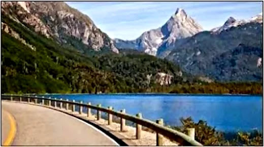 |
| Carretera Austral Image: tompkinsconservation |
Route 7, known as Carretera Austral, stretches over 1,200 km from Puerto Montt (Los Lagos Region) to Villa O'Higgins (Aysén Region). Still expanding, including the necessary ferry sections, it is projected to eventually reach Puerto Williams, the World's Southernmost City.
Due to the rugged terrain, some sections require ferry crossings. The mostly gravel road winds through breathtaking landscapes, making it a prime destination for travelers by car or bicycle. Proper gear, supplies, and weather-appropriate clothing are essential.
This ambitious Chilean government project has greatly improved access to northern Patagonia’s attractions. Highlights include Puyuhuapi and Queulat National Park, Pumalín Douglas Tompkins National Park in Palena Province, and Futaleufú, home to the world-renowned Futaleufú River for rafting and kayaking.
Queulat National Park
 |
| Image: Puyuhuapi Lodge & Spa |
Queulat National Park boasts breathtaking scenery, featuring waterfalls, a hanging glacier, deep cliffs, dense forests, lakes, and rivers. Located in the Puerto Cisnes commune, 165 km north of Coyhaique in the Aysén Region, it is one of the country’s most untouched areas due to its rugged geography, offering great tourism potential. The hanging glacier was discovered in 1875 by Captain Enrique Simpson, who noted it was just 100 meters from the sea. Today, it lies 7,800 meters from the coast.
Douglas Tompkins Pumalin National Park
Pumalin is a national park managed by CONAF, after its donation by Tompkins Conservation to the Chilean state. It covers 402,392 hectares, with 293,338 donated by Tompkins. Located in the communes of Cochamó, Hualaihue, Chaitén, and Palena in the Los Lagos Region, it is renowned for its stunning landscapes and was declared a Nature Sanctuary in 2005.
The park offers year-round access, with campgrounds and facilities. Visitors can enjoy adventure activities such as hiking, climbing the active Chaitén volcano, exploring ancient larch forests, rock climbing, sea kayaking, wildlife watching, and mountain biking on dedicated trails.
Marble Caves Natural Sanctuary

Explore Lake General Carrera and its stunning marble caves, sculpted by nature over centuries.
Officially named Capillas de Mármol (Marble Chapels), the site’s largest formation is known as the Marble Cathedral, a name often used for the entire area. When water levels are low, visitors can enter these mesmerizing caves, the most visited Natural Sanctuary in the Aysén Region.
Guided tours depart from Coyhaique and Puerto Río Tranquilo, on the lake’s western shore, lasting about 90 minutes.
Some local tour operators:Marmol Expediciones Whatsapp +56 965922759
Rafting in Patagonia
Patagonia offers exceptional rafting opportunities, particularly in the Aysén Region, where multiple rivers feature thrilling rapids. The Baker River, originating at the southern end of Lake Bertrand—southwest of General Carrera Lake—is a top choice for adventurers. The Simpson River, also popular for fly fishing and other water sports, provides another exciting option. Meanwhile, the Figueroa River, located 30 km from La Junta on the way to Lago Verde, offers an exhilarating experience. The Blanco and Aysén rivers form another ideal route for rafting enthusiasts.
However, the crown jewel of Patagonian rafting is the world-renowned Futaleufú River in Northern Patagonia, famous for its challenging rapids and breathtaking scenery.
Patagonia Elements - Tour Operator
📞 +56 977447250
📞 +56 974990296
📞 +56 992619441
Río Futaleufú Rafting
Recreational Fishing Programs
Local tourist agencies offer a variety of fishing excursions. The Patagonian regions of Aysén and Magallanes boast world-class rivers and lakes for sport fishing.
Aysén Region:
- Rivers: Baker, Simpson, Aysén, Azul.
- Lakes: Los Palos, Riesco, Elizalde, Azul.
Magallanes Region:
- Rivers: San Juan, Grande (Riesco Island), Grande (Tierra del Fuego Island), Cóndor (Tierra del Fuego Island), Azopardo (Tierra del Fuego Island), Tranquilo (Puerto Natales), Hollenberg (Puerto Natales), Serrano (Torres del Paine), Las Vizcachas (Torres del Paine)
- Lakes: Parrillar, Deseado (Tierra del Fuego Island), Blanco (Tierra del Fuego Island), Toro (Torres del Paine)
Comments
Post a Comment