 |
| Wikimedia Commons, by Freddy Alexander Bugueño Tolmo |
Iquique is a captivating port city in northern Chile, blending rich history with modern development. Once a Peruvian port, it became part of Chile after the War of the Pacific (1879–1884). One of the most heroic moments in Chilean history took place in its bay—the Naval Battle of Iquique, where Arturo Prat and his crew made their legendary sacrifice.
Today, Iquique is the thriving capital of the Tarapacá Region, experiencing rapid growth due to mining, industry, and its Free Trade Zone (ZOFRI)—one of the largest in South America. Beyond its economic significance, the city boasts a remarkable architectural and historical heritage, best appreciated by strolling through its vibrant streets.
With a population of over 220,000 residents, Iquique has also seen an influx of Latin American immigrants in recent decades, shaping its diverse and dynamic culture.
Known as Tierra de Campeones (Land of Champions) for producing outstanding athletes, Iquique is a top travel destination. Below is a list of its must-visit attractions.
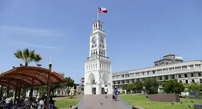
Torre del Reloj (Clock Tower)
 |
| Image: Vilas Radio 100.1 FM - Iquique |
Perhaps the most emblematic symbol of Iquique, in the middle of the Plaza de Armas (Arturo Prat Square). The structure was built in 1878 and the clock was imported from England.
Erected by order of the Peruvian Government, (since in those years Iquique was a Peruvian city), it is a National Historic Monument that constitutes one of the most representative urban expressions of the "nitrate era", built in Oregon pine, material impossible to find in a region surrounded by the Atacama Desert. The Chilean-French engineer Eduardo Lapeyrouse, had ordered the design of the tower and the clock to Europe in 1877, Lapeyrouse was later the first Mayor of Iquique when the city became Chilean in 1879. In 1884, it was located in the center of Plaza Prat, where it remains to this day.
Museo Corbeta Esmeralda (Corbeta Esmeralda Ship- Museum)
 |
| Image: Tarapaca Insitu Online |
The ship-museum on Arturo Prat Avenue with Paseo Almirante Lynch is a must-see in Iquique. It is a replica of the Esmeralda corvette, which belonged to the Chilean Navy and was sunk on May 21, 1879, during the War of the Pacific.
The museum was inaugurated in 2011 and provides an opportunity to learn about Chile's history. Surprising realism is achieved by considering every detail. The original plans were requested from England, and an investigation was conducted on the sunken ship to ensure the museum is as accurate as possible. The sound of the sea can be heard in every corner, creating the illusion that the ship is moving, although it is actually on land.
Paseo Baquedano (Baquedano Promenade)
The pedestrian promenade is lined with luxurious old mansions from the golden decades of Chilean saltpeter production in the late 19th and early 20th centuries. It has been a National Monument of Chile since 1977, categorized as a Typical Zone. Today, it is one of the most emblematic and historic areas of the city. Paseo Baquedano is a must-see tourist circuit. The buildings appear to have remained in the past when the train from the 'Oficinas Salitreras' ran along this route.
Teatro Municipal de Iquique (Municipal Theater)
The Teatro Municipal is a refined building located in front of the Plaza de Armas. It was built in 1889 and formally inaugurated on January 1, 1890. The building was constructed during the economic boom of the saltpeter industry (1880-1930) and is almost entirely made of Oregon Pine imported from the United States. Its central location makes it easily accessible. The Municipal Theater restoration is well underway and the remodeled building is expected to be completed in 2024.
Museo Regional de Iquique (Regional Museum)
The museum is located at 951 Paseo Baquedano, on the ground floor of a building that was constructed in 1892. It was founded in 1960 under the patronage of the Universidad del Norte and has been run by the Corporacion Municipal de Desarrollo Social de Iquique since 1982. Originally, the building housed the first 'Intendencia de Tarapaca' and then the Court of Justice.
The museum has three areas: anthropological, ethnographic, and historical. The museum offers insights into the regional past dating back 10,000 years. It covers the Chinchorro and Aymara communities, as well as other cultures that influenced the current North of Chile. Additionally, visitors can learn about the Tiwanaku (Tiahuanaco) and Inca cultures. The ethnographic section showcases the way of life of the Aymaras from their origins to the present day. The historical exhibit covers the Nitrate era from beginning to end.
The "ZOFRI" (Iquique's Free Trade Zone)
The ZOFRI is the largest commercial center in northern Chile and one of the most important in South America. It has become a must-visit for tourists, even though it was not initially intended as a tourist attraction. It promotes an important commercial exchange with neighboring countries such as Argentina, Bolivia, Peru, Paraguay, and Brazil. Consider spending at least one day visiting the ZOFRI Mall and facilities.
Beaches of Iquique
Playa Cavancha is the most popular and central beach in the city, located near the old quarter. It is surrounded by a modern urban architecture, the seashore, and a walking area. It covers a considerable length and has good conditions for outdoor and sport activities, like surfing and swimming.
Due to the influence of the Humboldt Current, the coasts of Chile are generally colder than those of the Atlantic. However, in Cavancha, the sea is warm, and visitors can swim year-round. The beach is extensive and offers various forms of entertainment. The northern sector of the beach is characterized by intense waves, making it suitable for water skiing, sailing, surfing, windsurfing, and bodyboarding.
Playa Brava, located 4 km south of downtown in a highly developed area of the city, is situated to the south. Playa Huayquique is not suitable for swimming due to its strong swell. However, it is an excellent spot for sport fishing, water sports, sunbathing, and paragliding. It also offers additional attractions that draw thousands of visitors daily. This beautiful beach is situated 5 km away. South of Iquique, there are excellent opportunities for surfing and bodyboarding when the wave conditions permit. The beaches are less crowded than Cavancha, making them ideal for sunbathing. Another option is Playa Blanca, which is located 13 km south of Iquique. It has white sands and transparent emerald waters, making it suitable for swimming, sport fishing, diving circuits, and various water sports.
The Majestic Giant of Tarapacá: An Ancient Enigma in the Atacama Desert
The Giant of Tarapacá is a breathtaking geoglyph located on Cerro Unita, about 80 km (50 mi) northeast of Iquique and 15 km (9 mi) from the town of Huara. Standing at approximately 119 meters (390 feet) tall, it holds the distinction of being the largest anthropomorphic geoglyph in the world.
Now designated as an Archaeological Monument, experts estimate that it was created between 900 and 1450 AD by pre-Incan cultures, possibly for astronomical or ritualistic purposes. Its design depicts a human figure with symbolic attributes, sparking various interpretations about its meaning. As one of the most captivating expressions of rock art in the Atacama Desert, the Giant of Tarapacá is a must-visit attraction for those exploring the region.
Saltpeter Refineries
Santa Laura and Humberstone, former mining towns declared a World Heritage Site, are located 46 km East of Iquique. They are like 'ghost towns' of what were once true cities called "Oficinas Salitreras". Chile was the world's leading producer of saltpeter at the end of the 19th and beginning of the 20th centuries. It should be noted that during the saltpeter boom, there were more than 200 'Oficinas Salitreras' working in the middle of the desert. This boom lasted until synthetic saltpeter was invented in 1930.
Volcán Isluga National Park
Located just over 230 km northeast of Iquique, near the Bolivian border, Parque Nacional Volcán Isluga sits at an average altitude of 4,000 m a.s.l. This protected area spans 174,744 hectares and boasts one of the most remarkable concentrations of biodiversity in the high Andean ecosystem. The landscape features a mix of precordillera terrain, vast highland plateaus, and small villages nestled in the mountains.
To the east, the imposing Isluga Volcano rises to 5,500 m, dominating the horizon and lending its name to the park. Besides Isluga, the park is home to other towering peaks, including Quimsachata (5,400 m), Tatajachura (5,252 m), and Latarama (5,207 m). Visitors can also discover geysers and hot springs, adding to the park’s striking natural beauty.
Pampa del Tamarugal National Reserve: A Desert Oasis in Northern Chile
Located 70 km inland from Iquique, in the communes of Huara and Pozo Almonte, the Pampa del Tamarugal National Reserve is a unique natural and cultural attraction in northern Chile. The reserve is named after the Tamarugo, an endemic tree that thrives in the region’s arid environment.
Despite its dry climate, the reserve is home to a diverse range of wildlife, including lizards and small snakes, which have adapted to the harsh terrain. It also shelters 18 protected bird species, such as the Tamarugo comesebo, eagles, owls, pequén, and red-headed buzzards. Additionally, culpeo and chilla foxes roam the area.
Pintados Geoglyphs: Ancient Art in the Desert
One of the reserve’s most significant cultural treasures is the Cerros Pintados Geoglyphs, declared a National Monument in 1969. This archaeological site features over 450 anthropomorphic, zoomorphic, and geometric figures, stretching across three kilometers. These geoglyphs, created over 500 years ago, are believed to be the work of the Tiwanaku culture.
To preserve and showcase these ancient markings, a Museum and Information Center has been established, offering valuable insights into their history and significance. Visitors can also explore the CEDAM (Environmental Education Center), located within the reserve’s administrative area. Open year-round and free to visit, this center provides a comprehensive look at the cultural and environmental history of northern Chile.


.webp)

Comments
Post a Comment