Easter Island, known as Rapa Nui in the native language and Isla de Pascua in Spanish, is a World Heritage Site and a Special Territory of Chile, part of the Valparaiso Region. Its area is 163.6 km², making it the easternmost island of Polynesia, Oceania. Located 2,191 miles from the nearest point in South America, its population reaches a little over 5,000, mainly concentrated in Hanga Roa, the capital.
The name "Easter Island" originated in 1722 from the Dutch explorer Jakob Roggeveen, who arrived there on Easter Sunday and decided to name it in commemoration of the day. Administratively, the island is part of Valparaíso, the Fifth Region of the country. Its geographical location, so far from other inhabited islands, makes it one of the most isolated places on earth. It is not for nothing that its ancient inhabitants called it Te pito o te henua (The Navel of the World). The volcanic origin of the island made it an ideal quarry for the primitive inhabitants to build the nearly 900 stone statues world-wide known as Moai, and the altars called Ahu.
As one of the most important tourist destinations in the country, Easter Island is accessible by cruise tours, charter, and regular flights. However, the most common way travelers arrive is through regular flights with the Chilean company LATAM Airlines from Santiago, landing at Mataveri Airport in Hanga Roa. Mataveri, which translates to "pretty eyes" in English, is considered the most remote airport in the world.
Another important volcano is Rano Raraku, which was formed more than 300,000 years ago. The rock formed by the surrounding lava served as raw material for building the Moai, key pieces in the development of Rapa Nui culture. Maunga Terevaka Volcano is the highest point on the island at 511 meters. It is the best place to appreciate the surrounding landscape in all its magnitude; it is advisable to choose a sunny day.
Poike Volcano is the oldest of Rapa Nui. According to estimates, it emerged from the seabed after two eruptions: the first occurred about three million years ago, and the second about nine hundred thousand years ago. Puna Pau is a small extinct volcano on Easter Island, approximately 7 kilometers from the town of Hanga Roa. It is interesting to note that the Pukao, a kind of hat made of reddish stone placed on the heads of the Moai, are made from red scoria extracted from the Puna Pau volcano. For more information, below is a list of the best tourist places and activities on Easter Island.
Parque Nacional Rapa Nui (Rapa Nui National Park)
Run by CONAF (National Forest Corporation), the National Park has its origins in 1935, but its current status dates back to June 1966. Declared a World Heritage Site by UNESCO in 1995, the park currently covers an area of 7,150 hectares, which constitutes 43.5% of the island.
Activities mainly include guided cultural tours, horseback riding, trekking, scuba diving, sea kayaking, surfing, recreational fishing, wildlife observation, and photography. The park offers food and crafts for sale, picnic areas, trails, lookouts, and horse rentals. Like any other National Park, there are basic rules to respect; failing to do so may result in significant fines. These rules include: Camping is not allowed, do not touch, scratch, or scribble on any archaeological remains, do not stray from established paths, and do not stand on Moai platforms (Ahu). Tickets can be purchased at Mataveri Airport upon arrival or at CONAF offices in Orongo and Rano Raraku.
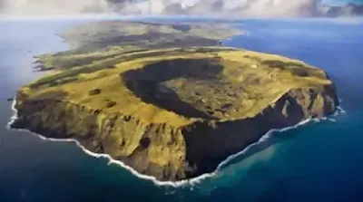
Rano Kau Volcano
 |
| Rano Kau Volcano - Image: isladepascua.travel |
Rano Raraku Volcanic Crater and the Moai
One of the must-see places in Easter Island. This is not only a volcano crater with a lagoon inside, but it has an immense geological and historical value since it was the quarry where the Moai were carved, being the place on the island where the largest number of statues is concentrated, with hundreds of moai at different stages of manufacturing. It is believed that the statues that had been built for about 1,000 years, may have been destroyed by the own islanders having lost faith in their power, or product of tribal wars for the exploitation of resources, another theory says that a tsunami may have devastated the island since some of the moai have been found on the seabed. Of the old Rapa Nui culture little or nothing is known with certainty, because in the second half of the nineteenth century Peruvian traffickers practically decimated the race.
Playa Anakena (Anakena Beach)
Though not of great extent, it is the main beach in Easter Island, certainly one of the most beautiful places to relax, located 18 Km. from Hanga Roa, following the road that crosses the island. Unlike the coast of central Chile, the waters are much warmer, marine life can be seen through the crystal clear waters, the sand is white, with palm trees and moai near, besides it is a beach visited by few people, which makes it very quiet. There are places to eat and buy crafts. From the beach of Anakena can be observed the row of seven moai known as Nau Nau, whose altar (Ahu), is still in good state of preservation.
Watersports and Underwater Tourism in Easter Island
 |
| The submerged Moai Impressive replica of the centuries-old statues |
The Navel of the World Stone
Te pito o te henua in Rapa Nui language, located 26 km. North of Hanga Roa, the capital of the island. It is a large round stone representing the navel of the world, the same name with which the natives call their island. The main stone is surrounded by another four smaller indicating the four cardinal directions. It is believed that the origin of Te Pito O Te Henua stone is from a meteorite and that was brought by King Hotu Matua from the former island of Hiva. The tradition is to put the hands on it to be charged with positive energy and is even said to increase fertility. Because of its high iron content, it heats up more than an ordinary stone and causes compasses to behave strangely.Maunga Terevaka Volcano
It is an extinct volcano located in the northern vertex of Easter Island, with its 511 mts. high is the highest point, to get to the top the stretch must be made on foot or horseback. Although in terms of landscape this is not the most attractive place, once there the surrounding view is stunning as it offers a panoramic of almost the entire island; you should bring at least a bottle of water because the climb is tiring. It is a recommendable to check the weather forecast because in case of rain or overcast day, it is better not to make the effort.Ahu Tongariki
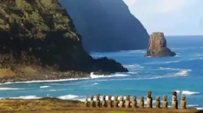
It is the largest Ahu (Moai Altar), located on the southeast coast, close to the Rano Raraku Volcano, consisting of 15 statues of imposing size, perfectly aligned and with different styles and features because they allegedly represented the forefathers. It constitutes one of the most representative views of the island. Despite the large tonnage of the pieces, this Ahu was devastated by the 1960 earthquake of Valdivia, 9.5 Richter scale and the tsunami that hit the coast of the South Pacific. However, at the beginning of the decade of the 90's, there was a restoration work that was carried out with great precision and with the support of the Government of Japan.Tapati Rapa Nui Festival
Museo Antropologico Padre Sebastian Englert

Image: registromuseoschile.cl
Father Sebastian Englert Anthropological Museum of Easter Island, founded in 1973 and located in Hanga Roa, the island's capital. The aim of the gallery is to collect, preserve and research the patrimonial heritage of Easter Island and its original ethnic group, the Rapa Nui people, owner of an enigmatic culture. It is named after the priest Sebastian Englert, a German Capuchin who came to the island in 1935 and dedicated 34 years of his life to the study and dissemination of the language, traditions and archaeological heritage of this mysterious people. There are panels with detailed information showing the history of Easter Island from its geological formation. The museum also houses the William Mulloy Library, so named in honor of a prestigious American archeologist, specialized in issues of Easter Island and Polynesia.


Comments
Post a Comment